
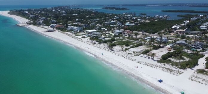
Town engineer’s annual report finds “unusually high” erosion, a $32 million renourishment waiting on federal permits, a rock groin field FEMA may help pay for, and a taxpayer bill that hinges on Washington, Tallahassee and Amendment 3.
—There is no infrastructure on Longboat Key more critical, or more valuable, than the beach.
—It is the island’s first line of defense when the Gulf rises. It is the town’s front yard and its playground. It is the reason visitors come from around the world, and it is what commands the tens of millions of dollars that Gulf-front homes and condominiums sell for. Every road, sewer pipe and property value on the island leans, one way or another, on its Gulf beach.
—So when the town’s coastal engineer stood before the Town Commission on Nov. 9 to deliver his annual State of the Beach report, two years after Hurricanes Helene and Milton tore across the island, the question in the room was a simple one. How is our beach doing?
—The answer: holding, in places, but losing sand faster than anyone expected. And the bill to put it back is coming due.
—Dr. Al Browder of Foth Infrastructure and Environment, one of the town’s coastal engineering consultants, opened with a warning about the slides on the screen behind him.
“They always teach you when you’re doing these PowerPoint presentations, ‘Don’t put things in red,'” Browder said. “But it needs to be drawn to everyone’s attention.”
—What the Survey Found
—Every summer, the town sends surveyors up and down the shoreline to measure the beach, from the dry sand out into the water. The data does two jobs. It tells engineers where the sand is going, and it gives the town hard numbers to back a FEMA claim if another storm hits.
—This year’s survey, the fifth since the 2021 islandwide renourishment, found increased erosion in most areas, particularly offshore in the shallow zone where swimmers wade out toward the sandbar.
—The numbers, as laid out in the town’s presentation:
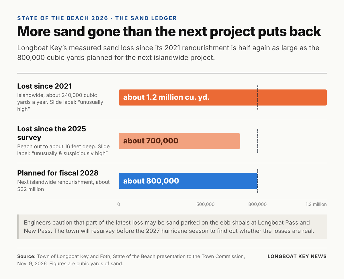
- About 1.2 million cubic yards of sand lost islandwide since 2021, which works out to roughly 240,000 cubic yards a year. The engineers labeled that rate “unusually high.”
- About 700,000 cubic yards lost since the 2025 survey alone, measured from the beach out to a depth of about 16 feet. That figure carried a sharper label on the slide: “unusually & suspiciously high.”
—Put those numbers next to the town’s plan and the problem comes into focus. The next islandwide renourishment, targeted for fiscal 2028, is designed to place about 800,000 cubic yards of sand. The measured loss since 2021 is half again as large.
“It’s an erosional beach. It does lose sand every year, so that’s not a surprise,” Browder said. “The rate of loss is noticeably higher than it has been in the past, so that’s a little alarming to us.”
—Unusually and Suspiciously High
—Browder was careful about the word “suspiciously.”
“That is not to draw doubts on the survey itself, but it is just to bring it to everyone’s attention,” he said.
—The losses in the nearshore were so large that Foth sent the surveyors back out to run the lines again. They ran extra lines. The second pass came back the same.
“Did not find anything to overturn the original survey,” Browder said, “but it is certainly something we need to keep an eye on here as we move towards our next renourishment.”
—Where the Missing Sand May Be Hiding
—Browder offered three reasons the numbers could be overstating the problem.
—The first is the passes. Both Longboat Pass on the north end and New Pass on the south end are ringed by ebb shoals, the big semicircular sandbars on the Gulf side of an inlet where outgoing tides deposit sand. There has been a lot of activity at both passes lately, and Browder said sand that left the beach may simply be parked there for now.
“It’s entirely possible that there’s a lot of sand currently trapped in the ebb shoals there,” he said. Foth is asking neighboring governments that have run projects at the passes for their survey data, to see whether the shoals have grown unusually in the past year. If the data doesn’t exist, the town will survey the shoals itself.
—The second is the measuring itself. Survey boats use fathometers that can only be so precise, and the town’s profile lines are 1,000 feet apart. If the survey catches the beach in an odd condition between those lines, it can show a gain or a loss that isn’t really there.
—The third is the storms. The 2024 hurricanes, Browder said, are still working their way through the system.
“The island is still apparently sort of shaking itself out, so to speak, in terms of its recovery,” he said.
—The bottom line: the town will survey again earlier than usual next year, before the 2027 storm season and before final design of the next renourishment, to find out whether the losses are real.
—The Good News: Where Sand Is Staying Put
—Not every stretch is bleeding.
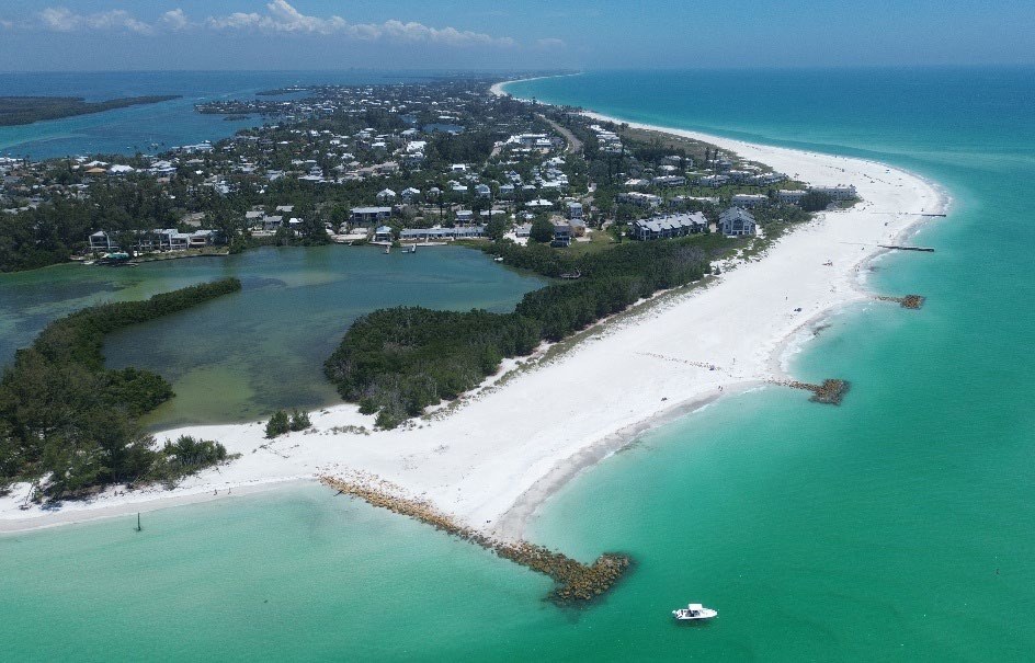
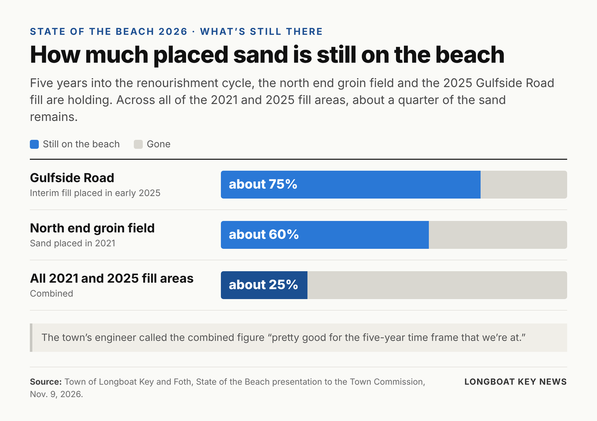
—The north end, where the town added rock groins in 2021, continues to fare well. About 60 percent of the sand placed there in 2021 remains, according to the presentation. Browder said the structures, now five years old, are starting to show some expected settling and sand loss, but the area is holding its design width.
—At Gulfside Road, the interim fill placed in early 2025 is about 75 percent intact. Browder said he had been down to look at it that very day.
—Across all of the 2021 and 2025 fill areas combined, about 25 percent of the placed sand remains. Browder called that “pretty good for the five-year time frame that we’re at.”
—The Hot Spots
—Ideally, Browder said, the beach would hold the same width everywhere.
“Mother Nature does not cooperate in that way,” he said.
—The town tracks the beach against a design width, and the same handful of trouble spots keep showing up:
- Gulfside Road, the island’s chronic erosion hot spot, always a struggle to hold.
- Buttonwood Cove to the Diplomat, where the beaches run narrow.
- The Islander Club groins, which Browder said have always been a challenge and remain one, holding up fairly well but still short of the target.
- The Privateer, near state survey monument R-22, where offshore shoal features push waves around and shape the beach.
- The south end at New Pass, where the shoreline swings with the inlet’s big ebb shoal. New Pass was dredged shortly before the survey, which may have played a role.
“We know we have hot spots,” Browder said. “We’re trying to knock them down one at a time.”
—Commissioner Sarah Karon asked what the engineers were hoping to see when they resurvey. Browder said he would like to see more recovery on the south end, which looked better that day than on his last visit, though he called that a qualitative impression. Some places, he said, will never be as wide as others no matter how much sand is pumped.
“It’s never going to be 300 feet wide and, and, you know, look like other areas of the island,” he said of Gulfside Road. “It just, Mother Nature doesn’t want it to be there.”
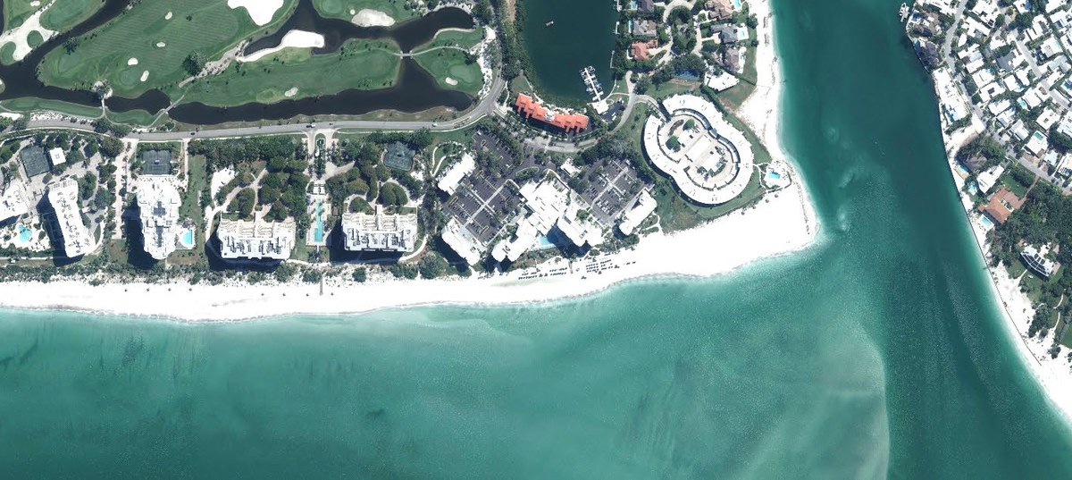
—Gulfside Road: Rock Instead of Just Sand
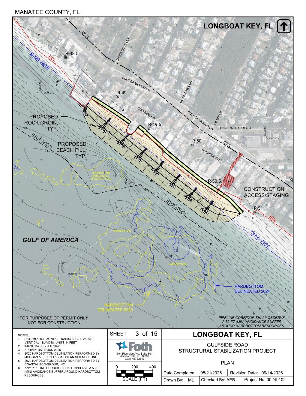
—For decades the town has poured sand onto the Gulfside Road shoreline, the stretch immediately south of the Ohana seawall, and watched it wash away.
“We’ve been through beach nourishment there on several occasions. We know what the rates are and they’re not generally very successful, so we’re trying to address that,” Browder said.
—The answer is a field of seven T-head rock groins, laid out on permit drawings revised Sept. 14, to hold sand in place along that stretch. The project is deep in permitting with the Florida Department of Environmental Protection and the U.S. Army Corps of Engineers. Foth is answering agency questions and running computer simulations to show the structures won’t starve the beaches downdrift to the south.
—The Florida Fish and Wildlife Conservation Commission has its own questions about how structures interact with nesting sea turtles.
“FWC does not like structures, that’s sort of a blanket statement,” Browder said, “and unfortunately, we have an erosion rate that sort of dictates that we have to do something structural to be able to keep up with the problem.”
—Regulators are also asking about the existing structures along the shoreline. Browder said they’re not in the best of shape but do protect the homes and roads behind them, and the town is working to fit new groins and sand around them.
—Construction is still aimed at fiscal 2028, which runs from October 2027 through September 2028. Browder declined to narrow that window.
“I’d like to give you a more specific time within fiscal 2028, and I don’t think I ought to do that,” he said, “since we’re kind of at the mercy of what regulatory agencies want to do with our permits.”
—The town hopes to combine the groin construction with the islandwide sand placement into one coordinated effort, though Browder noted they are substantially different jobs. One is sand. The other is rock.
“At What Point Does It Not Work?”
—Commissioner B.J. Bishop asked the question that hangs over every coastal town in Florida.
—She described family property on North Carolina’s Outer Banks that once sat about 200 yards from the high-tide line and now has waves breaking at its seawall. North Carolina, she said, has taken a far more aggressive stance on coastal structures.
“Barrier islands go back to being barrier islands,” Bishop said. “And as we continue to look specifically at Gulfside, because we’re getting ready to spend a bucket of money there with the groins, and we’ve got two properties that have seawalls halfway out into the Gulf, at what point does it not work? You know, at what point do you say, ‘This is not a responsible action to keep pushing sand here’?”
—Browder offered what he stressed was his own opinion.
“We’re in an age of sea level rise. We’re in an age of declining sand sources,” he said. “So we’re struggling, we’re fighting, we’re looking for sand wherever we can.”
—The groins, he said, are meant to end the cycle of refilling Gulfside Road every few years.
“It’s intended to hold sand so that we’re not going out there every two years, every three years with another round of nourishment, because we’ve tried it and it doesn’t, it’s not sustainable, you know, long term,” he said.
—But he did not pretend the engineering answers the larger question. A foot of sea level rise, he said, would bring more trouble than the island would know what to do with.
“I’m not really prepared to give you a really super smart answer to this right now,” Browder said. “And the state’s objection to having structures and this and that… Well, what would you rather see? I mean, there’s going to have to be some real fundamental changes in thought process.”
—His test for Gulfside Road was economic. If the structures pay off over a 30-, 40- or 50-year life, he said, they are a good investment. A century out, he said, he wouldn’t know what to tell the commission.
—Fixing the Islander Groin
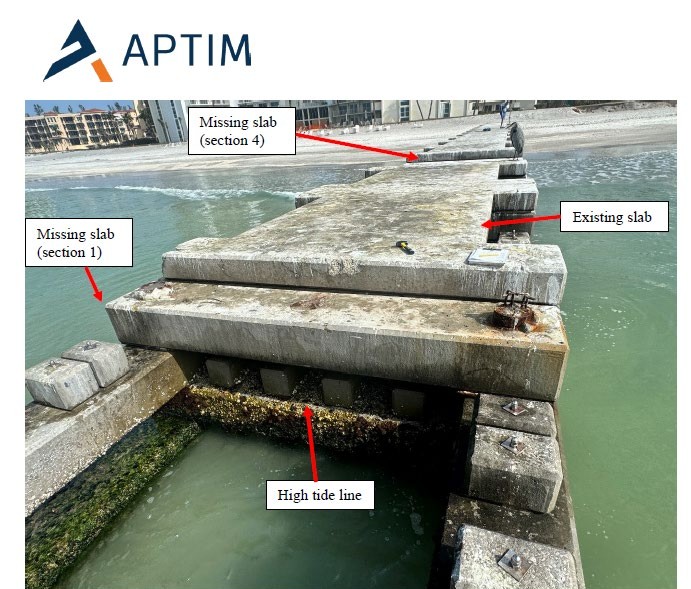
—One storm casualty is finally getting fixed.
—During Helene’s surge, two concrete platforms were ripped off the southernmost permeable adjustable groin at the Islander Club, said Public Works Director Charlie Mopps.
“Two of the platforms basically ripped off of the southernmost groin, and are sitting somewhere,” Mopps said.
—The repair was pushed into the new fiscal year for budget reasons. Permit exemptions are in hand from the state and the Corps, and the bid package is complete, with bidding set for November. The contractor will manufacture new prefabricated slabs, and crews will scoop up the old ones. The engineer of record who designed the groins, Doug Mann of APTIM, reviewed the specs.
—The work has to happen outside sea turtle nesting season.
“We should be able to get it done this winter,” Mopps said. The presentation estimated installation would take a few months.
—A Dune for Every Parcel
—The most visible change coming with the next renourishment may be a dune.
—The town’s beach permits are approaching their 15-year renewal, and Foth is using the renewal to add a dune to the design template: a slightly higher ridge of sand at the back of the beach, planted with sea oats, panic grass and other native species. A small version built with the last Gulfside Road fill is holding up well, Browder said.
—The new permit would let the town build a dune along every parcel on the island.
“We can specify to the next dredger and dredge contractor that, ‘Hey, we have the option to build a dune on every single parcel on the island,'” Browder said. “We will drop some of them if people have already taken action or they don’t want it, but the option will be there.”
—Helene made the case for higher ground.
“The more elevation you have, the better off we are, you know, especially with Helene,” Mopps said.
—Several condominium associations and homeowner groups have already rebuilt their own dunes since the storm, most of them landward of the erosion control line, which divides private property from the public beach. Mopps said the town has collected easements up and down the island so a public project can tie into those private dunes rather than tear them out.
—Mayor Debra Williams asked where the new dunes would sit. Browder said that for the most part they would be landward of the erosion control line, though some parcels could require dune work seaward of it, on state land. The starting point, he said, would be the pre-Helene dune line, drawn from the town’s extensive elevation data.
“One of the things we don’t really want to do is create like a checkerboard,” Browder said. “We want something that’s fairly uniform along the beach because that’s the way it was before.”
—If enough property owners want in, he said, the dune may become the default, built everywhere unless an owner opts out. That matters at bid time. Telling a contractor about extra shaping after the contract is signed means paying more.
“The more volume you can give a contractor, the better price obviously through economy of scale,” Mopps said.
—Condo Boards Want a Heads-Up
—Vice Mayor Penny Gold asked when property owners need to tell the town they want to take part. Mopps said a big outreach push will come once permits are in hand, so the message lands when it matters.
—One condo leader said that may be too late.
—Jeff Hecklau of Longboat Harbor told the commission that condo associations have already set their 2027 budgets and will start building 2028 budgets by the middle of next year.
“I think it would be advisable for an outreach program to be beginning early in January, February to meet with communities and talk about the impact of some of the things you’re suggesting with those new permitting so that we could stay ahead of it,” Hecklau said.
—Mopps agreed, pointing to groups like Condo Fed and the North End Coalition as ready audiences now that seasonal residents are returning.
—The Hunt for White Sand
“As we all know, sand is gold,” Mopps told the commission, “and, you know, getting the right quality and quantity of sand that is necessary in order to keep this nourishment going is a struggle in itself.”
—The good news: the town has enough sand lined up for the next renourishment. Its permits already include a borrow area off Passage Key, which Browder said will most likely supply the upcoming project, along with access to the navigation channels at Longboat Pass and New Pass and the option of trucking small amounts from upland sand mines.
—The passes work on a rotation. Under the town’s sand-sharing agreement with Manatee County, sand dredged from Longboat Pass in late 2024 and early 2025 went to Gulfside Road, and this fall’s round is going to Anna Maria Island. In September, the town signed a similar agreement with Sarasota County giving Longboat first claim on New Pass sand the next time that channel is dredged.
“We’ll be looking for opportunities to use sand here, there, everywhere, anywhere we can find it,” Browder said.
—The harder problem is the next decade. Foth is combing 30 to 40 years of core samples collected offshore by Longboat and its neighbors in Manatee and Sarasota, mapping search zones by priority. On the town’s map, the promising zones are shaded green.
“It’s like Charlie mentioned, it’s gold here,” Browder said. “Here, in this case, it’s green.”
—There isn’t much green. The offshore bottom is laced with hard bottom, reef and rock that can’t be disturbed, and much of the sand that is out there is too fine, or gray to black in color.
“We’ve got lots of areas where we have just absolutely terrible-looking material that you would not want to pump on the beach,” Browder said.
—The state regulates what can go on the beach. Mopps said the sand has to match the native beach closely enough for nesting shorebirds and sea turtles.
“Even though our beach looks amazing, it’s because we can put amazing sand on,” he said.
—Field sampling should take place over the next six to eight months, Browder said, and any new source will be added to the permit later rather than holding up the current renewal.
—Commissioner Steve Branham asked whether dredging the passes helps or hurts the beaches next to them. Browder said channel dredges typically take 200,000 to 300,000 cubic yards, possibly less at Longboat Pass, but taking too much from an ebb shoal will pull sand off the adjacent beach.
“If you take too much of that away, Mother Nature will start immediately trying to put it back,” he said.
—Permits: The Clock Nobody Controls
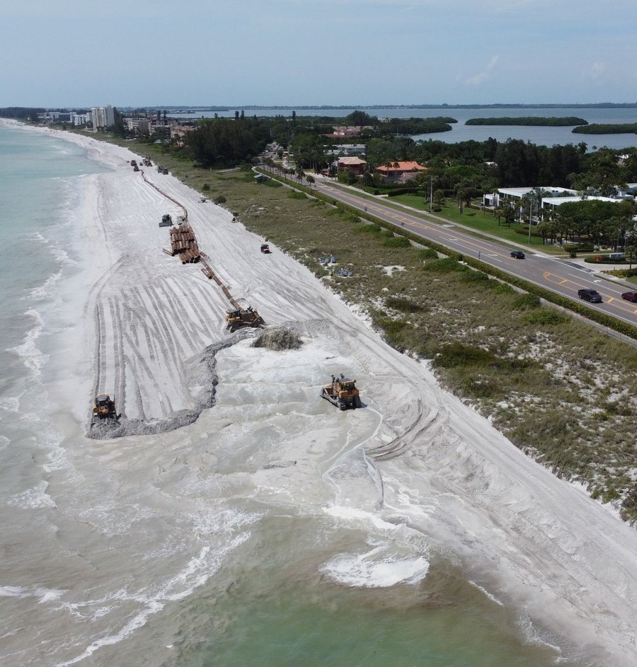
—The schedule for all of this runs through one office in Tampa.
—The town’s state permit remains active because the renewal was filed before the old one expired. The federal permit from the Army Corps of Engineers is another matter. It has to be replaced, and the application is still awaiting a finding that it is complete. Once it is, the Corps will mail public notices to beachfront property owners.
—Commissioner Nick Gladding pressed for specifics: has the application gone out to all the other agencies that must sign off? “That’s a very good question, and the answer is not yet,” Browder said. For the island-wide permit, the town has requested what are called programmatic consultations with the U.S. Fish and Wildlife Service and the National Marine Fisheries Service. The Gulfside Road groins require a separate, specific consultation with Fish and Wildlife about the structures, and that has not gone out yet.
“So we’re, ‘Hey Edgar, what’s happening?'” Browder said, referring to the Corps reviewer assigned to the town.
—Mopps said the reviewer, who is also handling the permit for the town’s $42 million subaqueous sewer force main, has given the town good guidance, and he knows where the beach ranks.
“He knows that this is priority number two, you know what I mean? It is, it is up there as far as the Town is concerned,” Mopps said.
—Both the renourishment and the groins remain targeted for fiscal 2028, subject to the Corps permit.
—Where’s the FEMA Money?
—Two years after Helene, the federal reimbursement for the beach still has not arrived.
—The town’s beach claim falls under FEMA’s Category G, which covers parks, recreation and beaches. In the town’s most recent public accounting in May, that category carried a federal share of about $17 million. Its centerpiece is the 407,300 cubic yards of sand the town says the storms took. Coastal engineers estimate Helene and Milton actually stripped about 629,000 cubic yards.
—As of August, FEMA told the town the beach project was in legally required environmental and historic preservation review. Overall, the town says it is owed roughly $28 million to nearly $30 million in reimbursements from the 2024 storms.
—Nothing presented at the Nov. 9 workshop indicated that the beach money has been approved or paid. But Mopps described a claim that has grown to cover more than sand.
“In it, our Cat G FEMA claim, we have not only the sand, but we also have in mitigation the plants,” Mopps said, referring to dune vegetation FEMA would supply, “but also the groins are in there. And so if it keeps moving forward, those things could be partially or fully covered by FEMA, and without cost to the Town, or a greatly reduced cost to the Town.”
—FEMA’s Idea: The Groins as Disaster Mitigation
—The groin piece is new, and it came from FEMA.
—In a memo to the town manager, Mopps described the transition of the Gulfside Road structural project into a “406-mitigation possibility,” a reference to the section of federal disaster law that allows FEMA to pay for improvements that reduce damage from future storms as part of repairing damage from the last one.
“When FEMA came and approached the Town and they said, ‘Hey, these coastal structures that you’re thinking about putting in there, we might want to consider those to be advanced mitigation,'” Mopps said. “And so we’re, as the Town, we’re just all in trying to get those structures, you know, provided to the Town at a much reduced cost.”
—The town’s capital plan carries about $7.2 million for the Gulfside Road stabilization. Mopps pointed to recent history as a reason for optimism.
“The last nourishment we did, we got 100% grant funded,” he said. “So all 100% construction grant funded, so didn’t cost the citizens anything.”
—Mayor Williams has said previously that the town intends to renourish whether or not the federal money comes through, because Longboat maintains an engineered beach and cannot afford to let it go.
—Tallahassee: Beaches Slide to No. 3
—The beach also came up earlier in the afternoon, when the commission met with its longtime lobbyist, Dave Ramba of Ramba Consulting Group, to set its priorities for the 2027 legislative session.
—Ramba’s advice was to keep the list short, because legislators will make the town choose.
“‘Which one do you want?’ That’s what they tell you,” Ramba said. “‘You’re not getting two, that just means you’re not getting two. You’re getting one.'”
—By consensus, the commission ranked state funding for the Gulf of Mexico Drive context-sensitive roadway and SUN Trail first, transportation and evacuation route congestion second, and continued state support for beach renourishment third. Protecting the town’s grandfathered short-term rental rules came fourth, and opposing state preemption of home rule fifth. The final list goes to the commission for approval Dec. 7.
—Ramba, who recommended that order, said Longboat’s beach money arrives as part of a bulk statewide appropriation based on the town’s prior projects, including the state-funded monitoring and science behind them, listed in the budget’s back-up documents rather than as its own line item. And he said the office of Sen. Jim Boyd, the Bradenton Republican who represents Longboat Key and is set to become Senate President, has been attentive to local communities’ needs.
“The issues you have on beach renourishment and things like that obviously are critical to this whole region’s success and tourism and everything else,” Ramba said. “I think those will continue to be funded by those folks at the levels they’ve historically been funded at.”
—State beach money comes with its own conditions. To qualify, the town must provide public beach access and parking near the funded shoreline, a requirement that has driven the expansion of parking at Bayfront Park, as Longboat Key News has reported.
—Ramba did flag one risk to coastal communities. Special districts funded by property taxes, he said, will be squeezed under Amendment 3.
“You look at West Coast Inland Navigation District, they’re a special district with ad valorem, they’re going to get cut. You look at the water management districts, they’re ad valorem, they’re getting cut,” Ramba said. “Some of those things that we historically have seen as coastal communities on dredging and programs will slow down.”
—On federal disaster aid, Karon asked whether Washington’s stated goal of shifting disaster costs to the states was weighing on Tallahassee. Ramba said it isn’t a front-burner concern for now, with Republican administrations in both capitals.
“Right now when we need it, you write a letter and you get it,” Ramba said. “So we have that advantage today. Whether we have that after ’28 with a new president, we don’t know.”
—The Amendment 3 Squeeze
—All of this lands on a town about to lose part of its tax base.
—Amendment 3, which raises the homestead exemption to $150,000 in its first year and $250,000 in its second, passed Nov. 3 with about 62 percent of the statewide vote, Ramba said. The town has estimated it will lose about $1.4 million a year in General Fund revenue once the higher exemption is fully in place.
“It’s going to start January 1, it’ll impact your next year’s budget fairly substantially,” Ramba said. “There’s not a lot of other places Longboat Key can shift money to.”
—He also warned that the Legislature is likely to block local governments from replacing lost property tax revenue with new special assessments, and said the state expects fees to rise on services that fall outside the core functions property taxes can pay for under the amendment.
—Ramba added that the exemption will do little for the owners whose taxes pay for most of the beach.
“I don’t know what, you know, an extra $100,000 is going to do to a home on the beach here,” he said. “Nothing.”
—What It Means for Your Tax Bill
—So what can taxpayers expect? The honest answer is that the bill depends on decisions made in Washington, Tallahassee and a Corps office in Tampa. Here is what is known.
—The project. The next islandwide renourishment is budgeted at roughly $32 million to $32.9 million for about 800,000 cubic yards of sand, about $41 a cubic yard. The town’s first islandwide project in 1993 placed 1.95 million cubic yards at about $5 a cubic yard.
—The funding plan. Town officials have penciled in about $12.2 million from FEMA, roughly $7 million in state grants and about $5 million in tourist development tax money from Manatee and Sarasota counties, with the rest coming from local funds. Depending on how the state and federal shares shake out, the town’s FY27 budget projected the local share at anywhere from $5.1 million (16.1 percent) to $12.7 million (39.9 percent).
—Who pays locally. Longboat’s beach program is funded through two beach erosion control taxing districts created in 1992. District A, which covers Gulf-side residential property west of Gulf of Mexico Drive and all commercial property, has historically carried about 80 percent of beach project costs. District B, everyone else, carries about 20 percent. Town officials have said they can raise up to an additional $13 million without a referendum, using the same method as the 2021 project.
—Saving ahead. The town’s FY27 budget proposal called for a $3.5 million beach tax levy in years when no beach debt is being paid, building a sinking fund to reduce borrowing and interest when the big project arrives. The beach program’s existing debt still requires dedicated millage.
—The groins. About $7.2 million is budgeted for the Gulfside Road structures. If FEMA treats them as mitigation, that cost to local taxpayers could shrink significantly, or disappear.
—The dunes. If the Category G claim keeps moving, FEMA would supply the dune plants. Property owners who already rebuilt their own dunes would not be asked to tear them out.
—The wild cards. A slow or shrinking FEMA payment shifts more of the bill to District A and District B taxpayers. A bigger-than-expected sand loss could mean a bigger project. And Amendment 3 leaves less room in the General Fund to absorb surprises.
—For condo boards. Associations budgeting for 2028 should expect the town’s dune outreach to begin once permits are in hand, though Mopps agreed to start the conversation sooner.
—What Comes Next
—Now through winter: Bid and complete the Islander Club groin repair outside turtle nesting season.
—Next six to eight months: Offshore field sampling in the search for new sand sources.
—Coming months: Prepare construction documents for the renourishment and the Gulfside Road groins as the permits take shape. Watch for Army Corps public notices mailed to beachfront owners.
—Dec. 7: Commission votes on the final 2027 legislative priority list, with beach funding ranked third.
—Coming months: Track down or collect new surveys of the ebb shoals at Longboat Pass and New Pass, to see whether the “missing” sand is parked there.
—Before the 2027 hurricane season: An earlier-than-usual islandwide beach survey to determine whether this year’s losses are real.
—Fiscal 2028 (October 2027 to September 2028): Islandwide renourishment and Gulfside Road groins, subject to the Army Corps permit.
—Once the field work is done, Browder said, he hopes to return with better news on the sand search.
“Come back to you and say, ‘Hey, we found great sand,'” he said. “That would be the objective of the whole thing.”
—By the Numbers
—1.2 million: Cubic yards of sand lost islandwide since 2021.
—240,000: Average cubic yards lost per year since 2021.
—700,000: Cubic yards lost since the 2025 survey alone.
—800,000: Cubic yards planned for the next islandwide renourishment, in fiscal 2028.
—$32 million to $32.9 million: Budget for that renourishment, about $41 a cubic yard.
—$5: Cost per cubic yard in the town’s first islandwide project, in 1993.
—60 percent: Share of the 2021 north end sand still on the beach.
—7: Rock groins proposed for Gulfside Road, budgeted at about $7.2 million.
—629,000: Cubic yards engineers estimate Hurricanes Helene and Milton stripped from the beach.
—$17 million: Federal share in the town’s FEMA beach claim, as of May.
—80 percent: Share of beach project costs historically carried by taxing District A, which covers Gulf-side homes and all commercial property.

