
—The Storms That Never Came…
Two years after Helene and Milton, the barrier islands have been handed the quietest hurricane season of the satellite era. The reason sits thousands of miles away in the Pacific. The catch is that it will not last.
—The latest deluge soaked Sarasota and the islands, and for anyone whose street still ponds, it was no small thing. But look at what it was not. It was rain without wind, rain without surge, rain without a hurricane attached.
—That is a test a coastal town can live with. A plain soaking shows which drains clog, which streets go under and which ditches still fall short, and it does so while the roofs, the seawalls and the power lines are left alone. It is the stormwater system being examined in a measured way, not the way a storm surge examines it.
—That is the pattern of the past two years in miniature. The big storms have stayed away, and the ordinary weather has been left to do its small, instructive work.
—Two years ago, on Oct. 9, 2024, Hurricane Milton came ashore at Siesta Key, 13 days after Hurricane Helene pushed the Gulf of Mexico through the ground floors of Longboat Key, St. Armands and Lido.
—Since then, nothing.
—The islands have spent those two years hauling sand, gutting drywall, jacking up houses and arguing with FEMA, all while watching every swirl on the satellite loop the way a person who has been bitten watches a dog. Two Junes arrived. Two Septembers passed. No hurricane has touched this coast.
—That is the biggest news nobody reported, because it is the news of something not happening. And the explanation has nothing to do with the war headlines, and nothing to do with anything Florida did. In 2025 the hurricanes formed and turned away. In 2026 they barely formed at all: eight named storms and not one hurricane through the first week of October, the longest wait for a first hurricane in the satellite era.
—The reprieve is real. It is also not a guarantee, and the last section of this story explains why.
2025: The year they all turned right
—Last year was not quiet. It only felt that way from the beach.
—The 2025 Atlantic season produced 13 named storms and five hurricanes, four of them major. Three reached Category 5, something that had happened in only one other year on record, 2005. Hurricane Melissa hit Jamaica in late October with 185 mph winds, tied for the most intense Atlantic landfall ever measured.
—None of them reached the United States. It was the first season since 2015 without a single U.S. hurricane landfall.
—The reason was steering. Through the heart of the season a persistent dip in the jet stream parked over the Southeast. Its counterclockwise flow acted like a traffic cop on the Atlantic seaboard, bending storm after storm north and out to sea before it could reach the coast. In one case two hurricanes, Humberto and Imelda, got close enough to tug on each other, and the stronger one pulled the weaker one away from the Carolinas.
—That was luck in the plain sense. The storms were there. The door happened to be closed.
—2026: The year they barely formed
—This year is a different animal.
—Through the first week of October the Atlantic managed eight named storms, Arthur through Hanna, and not one reached the 74 mph needed to be called a hurricane. The ninth, Isaias, finally got there on the night of Oct. 7. A normal season produces about 14 named storms, seven hurricanes and three major hurricanes.
The records have been falling in silence:
- —By Sept. 12 the season had passed the latest date for a first hurricane in the satellite era, Sept. 11, a mark shared by 2002 and 2013. The first hurricane did not arrive until Oct. 7, nearly a month later. By AccuWeather’s reckoning, that makes it the latest first hurricane on record, topping a mark set in 1905.
- —September ended without a hurricane for the first time in more than three decades.
- —The season’s total storm energy, a measure that combines strength and duration, stood near 11 units in early October, before Isaias. An average full season totals roughly 70 to 125.
- —With one hurricane so far, 2026 is on track for the fewest of any satellite-era season if no others form. The record low is two, set in 1982 and 2013.
“I don’t think anyone really foresaw it being this quiet,” University of Miami hurricane researcher Brian McNoldy told the Associated Press in September.
—The Science of a Lucky Break: It starts in the Pacific
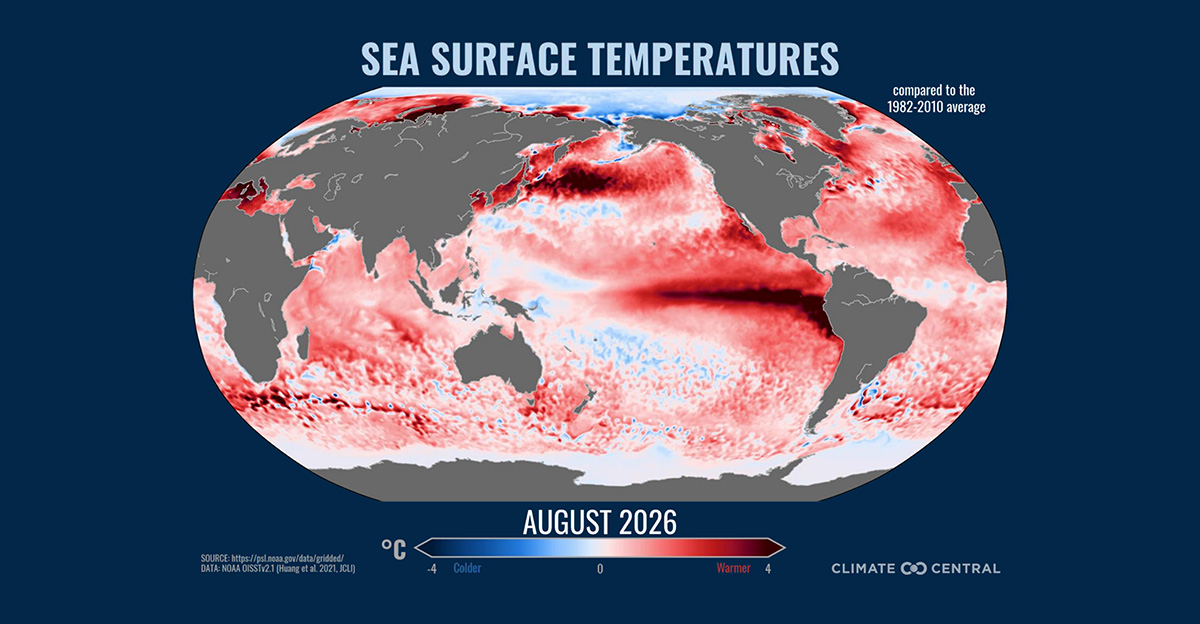
—The cause is El Niño, and not an ordinary one.
—El Niño is a periodic warming of the equatorial Pacific Ocean off South America. It emerged in June, strengthened all summer, and forecasters now rank it as the strongest ever recorded. A pool of abnormally hot water that size reorganizes the atmosphere around the globe, the way a boulder dropped in a stream changes the current far downstream.
—Colorado State University’s Phil Klotzbach, whose team issues the best-known seasonal forecasts, did not hedge when asked what killed the Atlantic season. “I think we really can pretty much put all the blame on El Niño,” he told the CBC.
—Forecasters saw it coming. NOAA called for a below-normal season in May and cut its numbers again in August. Strong El Niños have historically meant quiet Atlantic seasons, with 2023 the notable exception, when record-warm Atlantic water offset the shear. What nobody predicted was how close to a shutout this year would come.
—Wind shear: storms with their heads cut off
—A hurricane is a vertical engine. Warm, wet air rises in a tight column from the sea surface to 50,000 feet, and the storm only works if that column stays stacked like a chimney.
—El Niño sends a river of fast westerly wind across the top of the tropical Atlantic and Caribbean. Down low, the trade winds still blow from the east. A young storm caught between them gets its top sheared off and blown hundreds of miles from its base.
—This year that shear has been at record levels. In July, wind shear over the Caribbean was the highest in records going back to 1979. Across the main breeding ground between Africa and the islands, one researcher calculated the shear was running about 45 mph above what a tropical cyclone can survive.
—Sinking air and a starved sky
—Shear is only the first blow. El Niño also shifts where air rises and sinks around the tropics. The rising has been over the Pacific. The sinking has been over us.
—Sinking air warms, dries out and puts a lid on the atmosphere. Thunderstorms cannot build tall in it, and thunderstorms are the raw material of every hurricane. Add the usual outbreaks of dry, dusty air off the Sahara, and the middle levels of the Atlantic atmosphere spent the summer parched.
—Forecasters describe it as three punches landing at once: winds that decapitate a storm, dry air that starves it, and sinking air that presses down on whatever is left.
—What happened off Africa
—Most of the great hurricanes begin as ripples in the atmosphere over West Africa. These tropical waves roll off the coast near Cabo Verde every few days from July through September, and in an active year a steady share of them spin up over the long warm fetch to the Caribbean.
—The waves still came this year, though fewer and weaker. NOAA rated the West African monsoon that generates them as no better than neutral, and researchers reported a thinner supply of the seedlings that become storms.
—The ones that did emerge walked into a wall. Tropical Storm Dolly is the textbook case. Its parent wave left Africa on Aug. 24 and found a brief gap in the hostile conditions. It became a 40 mph tropical storm on Aug. 27, swallowed dry air, and was dead in a day.
—The water it crossed was also less of a help than usual. The tropical Atlantic between Africa and the islands ran cooler this summer relative to the record heat of recent years.
—The Gulf is hot. Why didn’t that matter?
—This is the question every reader on a barrier island is entitled to ask. The Gulf of Mexico is bathwater. Early this month the surface water measured about 88 degrees in the southern Gulf and about 84 off the northern coast. Either is enough to support a hurricane of any strength.
—The answer is that hot water is fuel, not ignition. A full gas tank does nothing for a car with no spark plugs. A hurricane also needs a calm column of moist, rising air above the water, and this year the atmosphere would not supply it.
—There is a subtler point. MIT’s Kerry Emanuel, who has spent a career on the physics, notes that storms are powered by the flow of heat from ocean to air. What matters is the difference between the two. El Niño heated the atmosphere over the Atlantic quickly, and the ocean has lagged behind. Narrow that gap and the engine loses power even over very warm water.
—What was different in 2024
—Run the same checklist for the year that wrecked us and every box flips.
—In the fall of 2024 El Niño was gone and the Pacific was sliding toward its opposite phase. Shear across the Gulf and Caribbean was low. The air was soaked. The Gulf was at record warmth. Helene organized in the northwestern Caribbean and Milton in the Bay of Campeche, and each found nothing in its way. Milton went from a tropical storm to a Category 5 in little more than a day.
—Has anything changed for the better? Not in the water. The oceans are as hot as they have ever been. What changed is the atmosphere above them, and that change is temporary.
—The Catch: The Gulf was the exception all along
One part of the map never fully joined the quiet. Wind shear over the Gulf of Mexico has been weaker than over the open Atlantic, and the three storms that struck the United States this year were all Gulf-born.
—Tropical Storm Arthur came ashore near Galveston in June and its remnants dumped close to 30 inches of rain on parts of Louisiana, a flood that killed four people and caused more than $1 billion in damage. Bertha formed in the northeastern Gulf in July and made landfall in Louisiana. Edouard hit near the Texas-Louisiana line on Sept. 1.
None was a hurricane. All of them formed in our ocean.
—The first hurricane, and where it formed
—When the season’s first hurricane finally came, it came from the Gulf. Isaias spun up in the southwestern Gulf, in much the same stretch of water that gave birth to Milton, and strengthened into a hurricane after slipping through one of the breaks in the shear that forecasters say still open from time to time.
—Forecasters expected it to strike the northern Gulf Coast, hundreds of miles to our north and west, leaving the Suncoast with rain, a gusty edge and rough surf. That is the soaking described at the top of this story, and not much more.
—The lesson is the one this section keeps returning to. The shear that smothered the Atlantic has been weakest in the Gulf, and the Gulf is where this coast’s real danger lives.
—October is our month
Hurricane season runs through Nov. 30, and for Florida’s west coast October has never been the epilogue. Milton arrived Oct. 9. Michael hit the Panhandle on Oct. 10, 2018. Wilma crossed Southwest Florida on Oct. 24, 2005.
—Late-season storms tend to form close to home, in the western Caribbean and the Gulf, and to be swept northeast by autumn cold fronts. That is the direction that leads here. A suppressed season lowers the odds. It does not close the calendar. The El Niño year of 1992 started late and then produced Hurricane Andrew.
—Forecasts change by the hour, so readers should check the National Hurricane Center’s latest advisory rather than rely on any newspaper.
—Next year’s bill
—El Niño events fade. This one is expected to weaken through the winter and spring. The warm water will remain.
—Emanuel’s warning is the one worth clipping and saving. As the Pacific cools toward normal, the storm-killing shear relaxes while the Atlantic and Gulf stay hot. That combination, he says, raises the odds that next season is a busy one.
—What two quiet years bought
—Time is the most valuable thing a battered coastline can be given, and this one has been given two years of it.
—It has been used. New vegetated dunes are going in along Lido Beach behind this year’s renourishment. Roughly 30 Longboat Key property owners are working to raise their homes, and 11 Florida west coast jurisdictions have rewritten zoning rules since the storms to make elevation easier. St. Armands and Lido are moving to bury their power lines.
—It has not all been progress. Longboat Key says it is still owed more than $28 million in federal reimbursement for storm costs, and town officials are now asking the state whether it will make good on Washington’s debts.
—The islands rebuilt, and then they waited. Each summer since 2024 has begun with the same private arithmetic in thousands of households: what is in the garage, where the documents are, how many days of notice there might be. That vigilance is its own kind of resilience, and it should not be mistaken for anxiety. It is what the storms taught.
—A record El Niño gave this coast a second year to get ready. The Gulf is still hot, the season runs through Nov. 30, and the atmosphere that protected us is already scheduled to change.

