
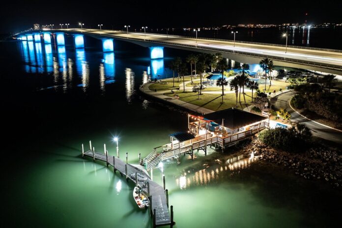
Plans filed with City Hall show a hurricane-hardened bait and restroom building pulled back from the bay, an open-air pavilion with bait tanks on the old dock footprint, and a floating dock with room for boats. What they don’t show: a price, a start date or who will run the place.
—The bait shop is coming back. It just won’t be standing over the water anymore.
—For two years, the only thing anybody could see at the eastern foot of the Ringling Bridge was a fence. Now, for the first time, there is a drawing of what comes next, and it answers the question fishermen, families and one very persistent podium regular have been asking since Hurricanes Helene and Milton: what goes back?
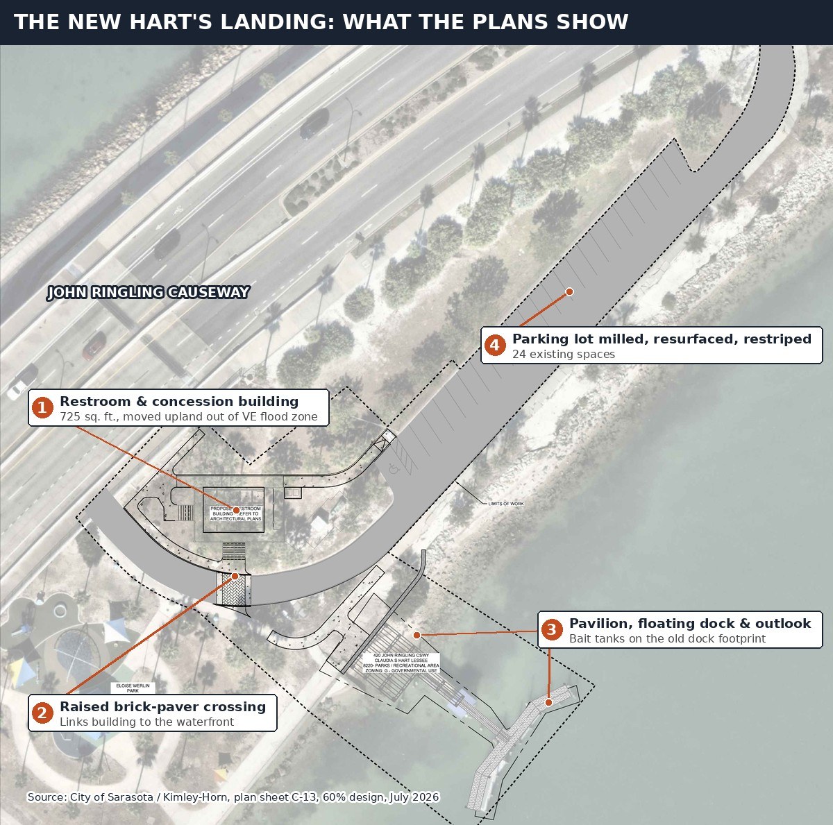
—The plans, filed Oct. 12 by the city’s consultants at Kimley-Horn on behalf of the Parks and Recreation Department, show a one-story, 725-square-foot restroom and concession building pulled back from the bay onto higher ground just south of the John Ringling Causeway. On the old dock footprint, where Hart’s Landing stood on pilings for six decades, would go an open-air shade pavilion with bait tanks. Out past it, a floating dock and an outlook platform. Back on land, a resurfaced parking lot, a raised brick crosswalk and a fresh skin of mostly native landscaping.
—The package goes before the city’s Development Review Committee on Nov. 4 as a pre-application conference, item 27-PRE-01, where city reviewers get to weigh in before the design is finished. It approves nothing, and while the meeting is open to the public, only committee members do the talking; residents get their say through workshops, appointments with city staff or later public hearings. But the filing is the public’s first real look at the new Hart’s Landing, and the drawings are much further along than anything City Hall has shown so far.
—Buy Up Top, Scoop Down Below
—The biggest change is how you will buy a dozen shrimp.
—For generations, you walked out the dock, stepped into the shop and bought your bait over the water. Under the new plan, you buy at a window in the concession building on the bank, cross the drive and walk down to the pavilion, where the bait tanks sit on the old dock footprint.
“The proposed pavilion will feature bait tanks that allow visitors to collect their bait after they have purchased them in the new concession building to the north,” the project narrative says.
—The consultants frame the whole thing as restoration. The project, the narrative says, “will restore a waterfront amenity that was damaged by storm events, reestablish public access to Sarasota Bay, and provide a safe, resilient facility designed to accommodate public recreational use.” It also notes, for the record, that it “does not propose to change the previously approved use.”
—A bait shop it was. A bait shop it stays.
—Out of the V Zone
—The reason the shop is moving is printed on the federal flood map.
—The old building sat in FEMA Coastal Flood Zone VE, the designation for a “Coastal High Hazard Area,” where storm surge arrives with breaking waves riding on top of it. Helene and Milton made the point the hard way. The city’s public works director has said more than 80 percent of the old building was destroyed, and what remained was razed Nov. 10, 2025.
—The new building goes “directly north of the previous location and just south of John Ringling Causeway,” to an upland spot outside the VE zone. “This relocation minimizes potential flood impacts to the structure while supporting safer and more sustainable site development,” the narrative says.
—Ten Feet Up, Built for 150 MPH
—The new building is designed to take a punch.
—The structural sheets put the floor at 10 feet on the vertical datum surveyors use, two feet above the 8-foot base flood elevation for its zone and nearly 10 feet above the bay’s mean high-water line, which surveyors fixed with a tidal survey approved this spring. The building sits on a raised concrete base, reached by stairs on two sides and an accessible ramp that climbs more than five and a half feet from the parking lot.
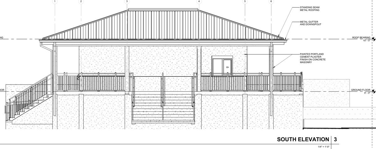
—The walls are concrete block finished in stucco. The roof is standing-seam metal over steel trusses, engineered for an ultimate design wind speed of 150 mph. The doors, the storefront glass and the bait window itself carry Florida impact-resistance approvals. A mesh bird deterrent runs along the roof ridge, which the pelicans may take personally.
—It stands about 10 feet to the eaves and 17 feet at the peak of its hip roof. The enclosed rooms cover roughly 32 by 23 feet, under a roof that reaches out to about 42 by 29 feet to shade a covered porch.
—Shrimp Window, Restrooms and a Bottle Filler
—Inside, the floor plan is simple. One side holds the concession room, with an impact-rated transaction window facing south toward the water, plus a storage room and a mechanical room. The other side holds the restrooms: three toilets on the women’s side, a toilet and two urinals on the men’s, each with an accessible stall. There is a baby changing station, and on the outside wall a hi-lo drinking fountain with a bottle filler.
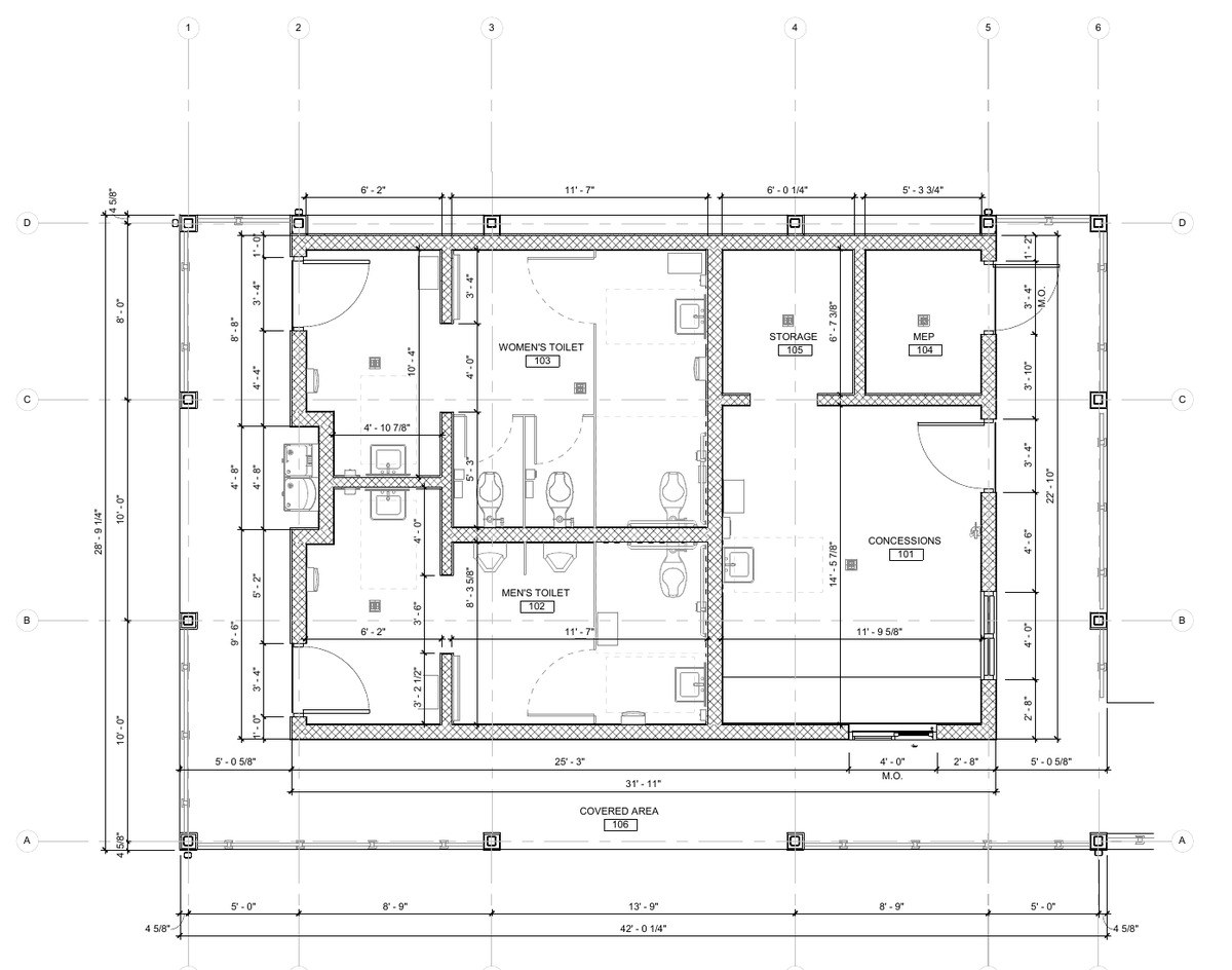
—For anyone wondering how many people the place is built to handle, the designers sized it for 125 at a time, counting the cars in the lot and four people for each of six boat spaces at the new dock. The plumbing count is calculated under the building code’s category for “stadiums, amusement parks, bleachers and grandstands,” which sounds about right for a Saturday morning when the mackerel are running.
—A Floating Dock and Room for Boats
—That boat count may be the sleeper in the packet.
—The site plan calls for a “proposed floating dock and outlook platform,” and the building’s life-safety calculation counts “new boat dock users” in six spaces. Hart’s Landing has always been a walk-up kind of place. If the dock is built as drawn, it becomes a boat-up place too.
—The detailed marine drawings for the dock and pavilion are referenced throughout the plans but are not part of the DRC packet, so their size and look are not yet public. The demolition sheets make one thing plain: the old wood pilings and dock come out entirely before anything new goes in.
—A Raised Crosswalk to the Water
—Between the building and the bay runs the curving parking drive. The plan bridges it with a raised pedestrian crossing paved in brick, essentially a speed table, linking the building’s 6-foot accessible sidewalk to the walkway down to the pavilion.
—The parking lot gets milled, resurfaced and restriped, along with a new dumpster enclosure, city-standard light poles, a relocated Adopt-a-Park sign and a mailbox. The old “BAIT SHOP PARKING ONLY” signs stay right where they are, according to the site plan. Some things should never change.
—Underground, the plan swaps the site’s old grinder pump station for a new sewage lift station, and the new walks tie into sidewalks being built under the separate Werlin Park improvement project next door.
—Sea Grape, Coontie and Cabbage Palms
—Thirteen trees come out to make room, four hardwoods and nine palms, replaced one for one under the tree mitigation plan.
—The landscape plan goes well past that. It calls for 16 cabbage palms, two royal poincianas, two green buttonwoods, 38 sea grapes and 96 Florida coonties, with beach sunflower, spider lily, sand cordgrass, railroad vine and pink muhly grass filling the beds and crushed shell underfoot. By the plan’s own count, 97 percent of the proposed trees are native.
—Mostly State Land Under the Bridge
—The city’s own parcel at 420 John Ringling Causeway is tiny, about 3,745 square feet, less than a tenth of an acre. The project spreads across roughly 38,254 square feet, or 0.88 acre, and most of that is Florida Department of Transportation right-of-way under and beside the bridge approach. The new building itself goes on state right-of-way.
—That adds one more agency to a project that already answers to FEMA, to the state emergency management office in Tallahassee and to the environmental regulators who watch over the bay’s seagrass and manatees. The erosion-control sheets call for floating turbidity barriers in the water and reference compliance with a Southwest Florida Water Management District environmental resource permit.
—The Hart Name Is Still on the Parcel
—One small line on the aerial plan sheet will stop anyone who knew the place. The label on the waterfront parcel reads: “420 John Ringling Cswy, Claudia S Hart, Lessee.”
—The shop is gone and the pilings are coming out, but in the records the drawings were built on, the Hart name is still attached to that piece of water.
—The packet does not say who will run the new concession, or on what terms.
—Where the Plan Comes Up Short
—The pre-application step exists so reviewers can flag problems early, and the plan’s own site data table hands them a few.
—Parking is the first. Using development standards borrowed from the neighboring Downtown Bayfront zone, the building plus its outdoor recreation area would call for 40 spaces. The plan provides the 24 already there, including one accessible space. The architect’s code sheet, for what it’s worth, counts 33 existing spaces in two lots, so somebody’s tally needs reconciling.
—Setbacks are the second. The table lists a 15-foot minimum rear setback, and the building is drawn at 12 feet.
—Bicycles are the third. The table works bicycle parking out to zero required and zero provided, at a spot beside a bridge that draws a steady parade of walkers, runners and cyclists every morning.
—None of that is unusual for drawings at the 60 percent mark, and a government-zoned park has room to adjust. But those are exactly the kinds of details a review like this is meant to catch.
—Drawn in July, Filed in October
—The plan sheets are stamped “60% Design Development” and dated July 17, 2026. The architect’s project files carry a telling label: “Harts Landing Phase 1.”
—That means the drawings were nearly three months old on Oct. 5, when residents lined up at the City Commission podium to ask why nothing was happening at Hart’s Landing, and Martin Hyde told commissioners it had “been crickets for two years.” City Manager Karie Friling answered with FEMA’s rules and a promise to do a better job explaining them. The designs were not shown that night.
—One week later, on Oct. 12, Kimley-Horn filed the pre-application request, listing the city, through Friling, as owner and applicant, and Parks and Recreation Director Jerry Fogle as the city’s project contact. Fawley Bryant Architecture of Lakewood Ranch designed the building. The filing fee came to $331.73.
—A Rule the City Didn’t Have to Follow
—Tucked in the back of the packet is a city administrative regulation signed when Tom Barwin was city manager. It requires Development Review Committee sign-off before the city bids any public works project costing more than $200,000, so engineers, utilities and planners all get a look before a contractor does.
—The same regulation also says this: “Work resulting from named storms or a declared disaster are not subject to this administrative regulation.”
—If anything counts as storm work, Hart’s Landing does. The city is bringing it to the committee anyway. In the city’s own process, that sign-off is the step that comes before a project goes out to bid.
—What the Packet Doesn’t Say
—For all its detail, the filing leaves some big blanks.
—No price. The “estimated construction value” line on the application is empty.
—No schedule. As of early October, the city’s hurricane recovery tracker listed Hart’s Landing as permit pending and in design, with construction expected to start in 2029, on the dock only, and the dock, shop and restrooms finished in 2031. Nothing in the new filing changes those dates on paper.
—No dock drawings. The marine plans for the pavilion and floating dock are referenced, not attached.
—No word on music. Under operator Sherman Baldwin, the park beside the shop became a free concert venue. This application covers restrooms, bait and boats, not bands.
—No pier. The Tony Saprito Fishing Pier is a separate project on the tracker and is not part of this application.
—The FEMA Question
—The new design also raises the question City Hall says governs everything: the federal money.
—In FEMA’s accounting, as city officials have described it, this one shoreline is five separate projects, with the Hart’s Landing building and the Hart’s Landing docks and restrooms filed separately. The new plan folds the restrooms and concessions into one building, moves it onto state land and puts a pavilion where the old building stood.
—Federal disaster rules generally allow a community to build back differently, and moving a building out of a coastal high-hazard zone is the kind of change resilience programs exist to encourage. But departures from the original structure typically need FEMA’s blessing, and the packet does not say whether that has been sought or granted. With Friling warning that the city “cannot do anything to jeopardize” its FEMA reimbursement, it is the question worth a clear public answer before the first piling goes in.
—Back to the Rail
—For a business that started in 1934 with Deamus Hart, a hundred-foot shrimp net and a bonfire on the beach at Golden Gate Point, a stucco building with an impact-rated bait window is a long way to come.
—But read the drawings closely and the bones are familiar. A window where you buy your shrimp. Tanks by the water where you scoop them. Shade, a rail, a dock, the bridge overhead and the pelicans working the same water you are.
—Ed McCaffrey told commissioners on Oct. 5 that he is down at the water twice a week and would like to enjoy it in peace. The plans don’t tell him when. For the first time in two years, they at least tell him what.

